
Rising high above the shores of Derwentwater stands the distinctive shape of Catbells, one of the best-loved fells in the Lake District. At 451 metres (1,480 feet) tall, Catbells offers incredible views across Keswick and the Northern Fells while still being reasonably accessible to most walkers. As such, the path to Catbells summit sees thousands of hikers every year.
The route up Catbells begins with a gentle incline along well-maintained paths to the viewpoint on the southern ridge. From here, the higher summit comes into view, requiring a rockier scramble to reach the top. At the summit, most hikers take time to soak in the panoramas of Derwentwater shining hundreds of feet below and Skiddaw looming in the distance.
On a clear day, the views stretch as far as Blencathra to the north and the Helvellyn range to the south, encompassing the whole of the Northern Lake District. Even on wet and misty days, the atmospheric fells surrounding Catbells have their own drama and charm. Whenever conditions allow, the Catbells ridge warrants slow, mindful hiking to appreciate everything it offers walkers willing to make the ascent.

The Catbells Walk
The standard Catbells walk is a 3.5-mile loop that most hikers complete in 2-3 hours. It follows a simple but steep route to the twin summits of Catbells and back down to Hawes End or Portinscale. Underfoot conditions range from good tracks to rockier sections requiring some surefooted scrambling.
The walk starts from one of the main car parks serving the hill. On the Keswick side, the Hawes End car park sits at the foot of the hill looking towards the major summit. From Portinscale, the walk begins slightly further north at the NT Skelghyll car park, extending the route but avoiding road walking.
After a short walk on a country lane, the main ascent onto Catbells begins as the path climbs through bracken towards the first summit viewpoint. Sitting at 429m (1,407ft) high, this southern top offers the first stunning scenes, including the full Skiddaw massif. From here, most walkers push on towards the higher 451m (1,480ft) summit, requiring some easy scrambling and moments of exposure.
After soaking in the panorama, a steep rocky descent leads back to the wooded valley between the summits. Turning south here, the route soon reconnects with outward paths, allowing loop walkers to soon return to their starting point. With the majority of the ascent complete early on, the walk ends with gentle descent that's often a relief for tired legs.

Catbells Summit Views and Sights
The sense of height and space at the Catbells summit gives it an airy, majestic feeling looking out across the Lakeland scenery. On clearer days, the panorama stretches northwards to the mighty slopes of Blencathra and Skiddaw. Closer at hand, Keswick nestles around the River Greta while Derwentwater gleams enticingly 500ft below.
Looking southwards from the top, the views take in the serrated peaks of the Central Fells, including the distinctive pyramid summit of Grisedale Pike. On the clearest winter days, glimpses of the Southern Lakes are even possible in the distance. Beautiful Bassenthwaite Lake also comes into view southwards.
Back across Derwentwater lie the grassy domes of Latrigg and Skelghyll woods, framing views of the Grasmoor and Causey Pike summits. The full majesty of Lakeland unfolds in nearly 270 degrees of surrounding fells with Catbells at the centre. It makes a perfect introduction to the area for first-time visitors.
Even when the clouds or rain set in, obscuring wider views, Catbells has an allure all of its own. Just below the summit, a tarn pools between wind-sculpted crags and rock formations. Wild ponies graze the upper slopes here, lending Catbells an untamed feel. And when the weather clears, rainbows often arc over the northern fells as clouds break and sunlight bursts through.

Catbells Weather, Best Conditions and Difficulty
Weather conditions play a huge part in determining hiking experiences on Catbells. As an exposed, windswept summit, it bears the full brunt of hostile weather sweeping in from the Irish Sea. But in fair conditions it also enjoys one of the sunniest, most breathtaking vantage points in Lakeland.
The Lake District fells are famed for their changeable weather, swinging from glorious sunny spells to driving rain and cloud within hours. Generally though, the area has a mild climate thanks to warming winds blowing in off the Atlantic. Summer tends to offer the most consistently sunny hiking conditions. But all seasons have their own appeal.
Spring sees carpets of wildflowers blossoming below the summit after winter snow melt and rainfall. Lambing season also adds to the new life emerging across high pastures. Shows of spring daffodils light up woodlands like Skelghyll just below the summit.
Summer is prime hiking season with long days, reliably warm weather and only occasional afternoon showers interrupting blue skies. The golden evening light after a hot sunny day casts a special glow over the fells. But popularity also means summer crowds on routes like Catbells.
Autumn brings rich russet shades to surrounding lakeland woods and fiery bracken slopes. It's often still mild enough for T-shirts at lower levels into October. Clarity after overnight rain produces super clear distant views across the valleys. But higher fells see the first of the winter snows.
Even through the quieter winter months from November onwards, experienced hikers relish the challenge of frosty paths and wintery panoramas. After cold snaps and snowfalls, icy views transform the mountain landscape entirely. Crampons and other winter gear then become essential though for continued safe access.
In terms of difficulty, the main Catbells routes require a reasonable level of fitness to make the ascent and cope with some rockier sections. Beginners regularly complete the walk but some mobility and surefootedness helps considerably over certain parts. Experienced hillwalkers often incorporate Catbells into longer ridge hikes across multiple Wainwright fells.
Catbells Car Parks and Starting Points
The walk up Catbells begins from one of three main car parks providing easiest access. The location determines aspects like total distance and difficulty. But they all connect with the same network of established Lake District paths onto the high slopes.
Hawes End offers the shortest route up Catbells at just 2.5 miles. Sitting right under the Skelghyll Wood corner of the fell, paths lead almost directly up onto the peak. There's a small parking charge in summer and spaces fill quickly, though. So aim to arrive early, especially on sunny weekends when demand spikes.
A slightly longer alternative is the Portinscale car park which sits around half a mile north. Following a footpath southwards parallel to the shoreline soon links up with the main Hawes End route. There's no charge here and more spaces available generally. But the extra road walking isn't always ideal at busy times.
For a quieter outward walk avoiding any roadside hiking, the NT Skelghyll Wood car park is recommended. Located off the A591 further north still, it has more capacity. But it adds just over a mile each way, making the total walk closer to 5 miles. Well-surfaced tracks through the woods provide a pleasant warm up though before ascending Catbells.
Bus services also provide access to Catbells for walkers arriving without cars. The 77/77A bus from Keswick stops at Hawes End while Services 78/79 traveling between Keswick and Portinscale stop at the Latrigg turning for the footpath start there.


Ascent of Catbells from Hawes End
The shortest route at 2.5 miles long ascends from the Hawes End car park at the foot of Catbells. After a short road walk, it climbs steeply via the Machine Walk towards the first summit at Brownrigg. Some easy scrambling then leads along the airy ridge linking the twin tops of the fell.
On leaving Hawes End car park, cross the B5289 carefully to pick up the footpath opposite without any road walking required initially. Known as Spooney Green Lane, this quiet tarmac track soon bends left past farms to become a stone-pitched bridleway called the Machine Walk. True to its name, this served camelback trains hauling slate downhill from local quarries.
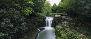
The Machine Walk soon begins to climb past a small cascade waterfall. After heavy rainfall this section can be quite wet and muddy underfoot. But the grade is steady without being too severe at this stage. As height is gained views back down towards Derwentwater improve with each turn.
Passing old quarries and workings, the track zigzags uphill entering the Catbells reserve through a gate. Bracken slopes start to close in as the path weaves onwards and upwards. With Derwentwater disappearing from view, occasional breaks in the vegetation provide glimpses of Skiddaw across the valley.
The final approach to the first summit at Brownrigg climbs directly up a grassy spur. Shaped almost like a ski jump, this steep slope often proves the most challenging part for new hikers. But it soon flattens out to a junction where the Skelghyll Wood path arrives from the north to merge with the route.
The southern viewpoint summit at Brownrigg now sits a short walk away to the right. At 429m (1407ft) high it gives a taste of what's to come in terms of vistas. The distinctive slopes of Catbells proper also beckon enticingly just across the col.
Ridge Walk to Catbells Summit
The airy ridge walk from Brownrigg to the Catbells summit presents one of the most thrilling stages on this popular Lakeland hike. Easy scrambling connects the two tops but involves some exposure at places, so surefootedness and a good head for heights help.
Setting off northwards from the junction the path remains rocky but avoids any real climbing at first. Instead it leads pleasantly along the escarpment soaking up scenic views all around. Rough grasslands dotted with hardy fell sheep graze the slopes to both sides.
Soon the onward route begins twisting uphill once more via eroded steps formed through the rock. As the grade steepens again, a little easy scrambling is required using hands for extra balance in sections. Care is needed during slippery conditions with steep drops falling away to the east.
The final approach traverses the upper craggy fellside heading directly up towards Catbells' summit, now revealed in all its majestic glory. The path weaves skilfully along outcrops and rocky shelves, avoiding the worst steep sections but still requiring some nimble footwork.
One last short steep rise negotiated via rocky steps ends the scrambling. The top suddenly flattens out to reveal the cairn and trig point marking the highest point of Catbells summit at 451m (1480ft). Hard-earned views stretch out on all sides making the final climb truly worthwhile.
After pausing a while to appreciate surroundings, most hikers will retrace their steps back to Brownrigg rather than following any direct descent route. Care is still required negotiating the same rocky steps and scrambles downhill before the path levels out once more on the approach to the low point between the two high points.
Descent to Hawes End from Catbells
After soaking in the scale and splendour of the views from Catbells summit, thoughts turn to the knee-jarring descent back down to valley level. Most walkers retrace the main ascent route all the way to complete a simple out-and-back circuit.
From the rocky platform of Catbells' highest point, the path heads northeast on a direct line towards the clear gap visible in the scarp ahead. This heads diagonally downhill aiming roughly for the corner point of Derwentwater near Brandelhow Woods across the valley.
Underfoot conditions remain stony and uneven to begin with, continuing the theme of needing surefooted steps. But a little way below the summit the angle starts to gradually ease as the path winds downhill into the gap between Catbells and Maiden Moor on the other side.
Soon the way bends round to head southwards on a clear descent route through the valley pass. Surrounding peaks still loom tall overhead but views open up ahead too now towards Bassenthwaite Lake and the grassy hump of Castle Rock.
The path grows easier for a time, crossing becks and passing little pools as it continues down across the grain of the hillside. Rowan trees offer occasional shade as the valley continues ever-downwards with the bulk of Catbells rearing up behind.
Eventually familiar views open up once more with Derwentwater coming back into sight ahead. Entering managed woodlands again signals the final mile as the route returns to lower slopes via quarries and connecting tracks. Before long the car park at Hawes End appears amidst the trees.
After the long descent, the final half mile back along the lane to complete the circuit will likely test tired legs and sore knees. But a sense of achievement mental blankets any physical discomfort for most hikers. And the promise of refreshments back at nearby Keswick adds positive focus to the walk's climax.

Alternative Routes and Extended Hikes
While most walkers are happy simply completing the standard Catbells circuit, the area offers scope for longer adventures via extended ridge walks. Routes can stretch for up to 10 miles by linking in other neighbouring Lakeland peaks.
Heading north from Catbells leads across the adjoining fell Maiden Moor to provide panoramic balcony views over Derwentwater. From the 514m (1686ft) summit here, continuing north on High Spy gives even wider vistas taking in much of the Northern Lakes.
Southwards from Catbells meanwhile, a short ascent leads to Little Man summit at 432m (1417ft). This extensions heads towards Grisedale Pike across Hopegill Head adding more varied scenery and terrain. Challenging walkers can continue as far as the 773m (2536ft) summit of Grisedale Pike itself.
For peak-baggers looking to tick off multiple Wainwrights, combining sections of all these fells makes for an hugely rewarding longer adventure with distances up to 10 miles depending on the precise route. Just make sure to have OS maps, proper navigation skills and enough food and water for full day expeditions.
Shorter alternatives include simply extending the basic Catbells circuit to take in Little Man or branching off northeast from the main descent to visit the cascades at Cat Gill. Adding sections like these provide extra interest while only slightly increasing overall distance and difficulty.
So while most visitors are happy with the standard Catbells route, the fell readily lends itself as a launch pad to explore the surrounding Lakeland peaks and valleys on foot. Just be sure to match extensions to your experience, fitness and prevailing weather conditions when venturing further.
Travel and Accommodation around Catbells
Nestled at the peaceful northern end of Derwentwater, Catbells enjoys a scenic setting conveniently close to Keswick town for amenities. But the wider Lake District also offers plentiful accommodation options to suit all budgets.
As the nearest major Lakeland hub, Keswick offers a great base for exploring Catbells and other Northern Fells. The market town boasts a range of hotels, guesthouses, B&Bs, hostels and campsites to meet most needs and budgets. Dining options also cover everything from cosy cafes and traditional pubs through to award-winning restaurants.
Nearby villages around Derwentwater like Portinscale and Grange also offer quieter rural lodgings with excellent lake views towards Catbells. Premium hotels dot the wooded banks and fields edging the shores here for upmarket stays surrounded by nature.
Windermere village at the heart of the Central Lakes sits only 20 miles south but sees less dramatic mountain scenery. Pretty villages further northwest like Buttermere and Cockermouth provide good alternatives beyond the busiest tourist trails. Here traditional Lakeland cottages and farms extend warm hospitality in idyllic settings.
In terms of travel, regular bus links connect Keswick with other Northern towns. Otherwise tourists often tour between key sightseeing spots by private car or on organised bus trips. But simply getting out on foot allows slow immersion into the special landscapes places like Catbells offer.
So while enjoying home comforts after the walk is a treat, experiencing the fell itself always proves the main highlight and richest reward for making the ascent. As the unique views from the top demonstrate, some treasures only reveal themselves to those prepared to climb higher and venture further afield from standard trails.


Related Articles
Let us know you agree to cookies
We use marketing, analytical and functional cookies as well as similar technologies to give you the best experience. Third parties, including social media platforms, often place tracking cookies on our site to show you personalised adverts outside of our website.
We store your cookie preferences for two years and you can edit your preferences via ‘manage cookies’ or through the cookie policy at the bottom of every page. For more information, please see our cookie policy.